To define the position of points on the Earth's surface we need geodetic reference systems. Reference system is a collective name for systems for determination of positions in one, two or three dimensions.
SWEREF 99 – the national three-dimensional reference system
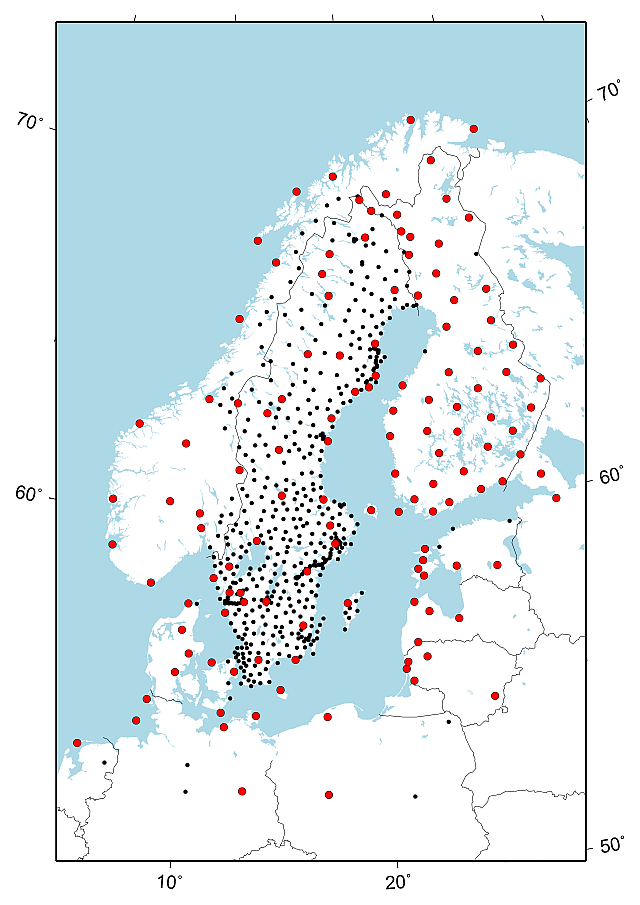
SWEREF 99 is the official reference system for positioning used in Sweden today. SWEREF 99 stands for Swedish Reference Frame 1999 and is a realisation of the European reference system ETRS89.
The relation to WGS 84
WGS 84 and SWEREF 99 differ by 8–9 dm for the time being (2024); increasing with time as the European plate moves. Thus SWEREF 99, WGS 84 and the previous frame SWEREF 93 are interchangeable for many applications.
Computation of SWEREF 99
SWEREF 99 is a realisation of ETRS89, performed in accordance with the EUREF guidelines, and was adopted as an improvement and extension of ETRS89 at the EUREF Symposium held in Tromsø, 22–24 June 2000. For further information, see the proceedings from the symposium (pdf, new window).
Review of SWEREF 99
The SWEREF 99 coordinates of the SWEPOS stations that are defining the reference system SWEREF 99, were updated in the beginning of 2021. Since the original SWEREF 99 campaign, the coordinates of the SWEPOS stations have been updated when necessary, e.g. when antennas are changed and when new antenna models and computation strategies have been introduced.
The purpose of the review and the following coordinate update is to achieve a more homogeneous SWEREF 99 that will be more sustainable for the future. An overall measure has been taken to obtain a reference system that is consistent with today's measurements and computations.
The number of defining stations has increased with the update, to some thirty stations in Sweden and, in addition, approximately 100 stations in our neighbouring countries. The number of foreign defining stations will however decrease with time, since we don't have the ambition to determine all foreign stations anew when they are altered.
The differences between the previous and the updated coordinates are, on the whole, small and lie within the specifications of the Swepos services.
Related information
Transformation between ITRF and SWEREF 99.
Map projections referred to SWEREF 99
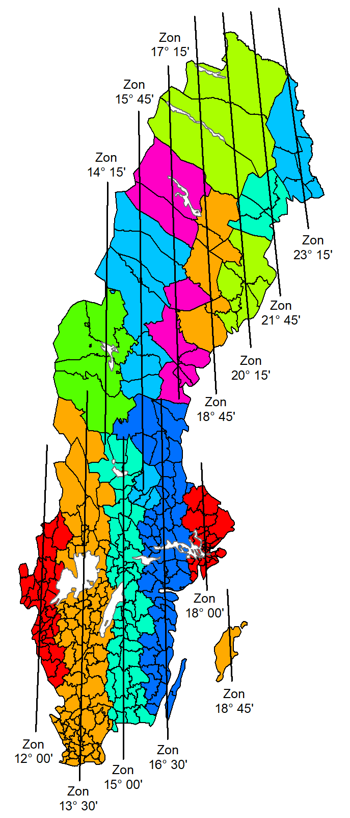
There are thirteen different map projections referred to SWEREF 99. SWEREF 99 TM is used for applications at the national level, and there are twelve local projection zones to be used for applications at the local level.
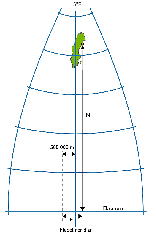
The Gauss conformal (Transverse Mercator) projection satisfies requirements regarding conformality and is also well-suited from other standpoints. On the projection plane (the mapping plane) a two-dimensional Cartesian coordinate system is used, in which N (Northing) coordinates are measured northward from the Equator, which has an initial N value of 0 metres; and E (Easting) coordinates are measured from the central meridian, increasing eastwards.
National map projection – SWEREF 99 TM
It is an advantage for many different applications at the national level if the whole Sweden can be mapped seamlessly, i.e. on one projection with positions given in one coordinate system. A rigid application of, for example, UTM in Sweden would require a division into three zones.
The definition of a dedicated projection based on a meridian 15° E of Greenwich, with a scale factor of 0.9996, with the Equator as the origin for N coordinates and with E coordinates measured from the central meridian and increasing eastwards (the central meridian is assigned a value of 500 000 m to avoid negative values) will give consistency with UTM in the major part of the country.
Local projection zones
For applications at the local level, such as local authority technical activities, the projection must be designed in such a way that the inevitable deformations can, in most cases, be ignored. The most obvious deformation is variations in scale, which increase with distance from the central meridian. Scale changes can be kept at a reasonable level by limiting the area of validity for the projection both eastwards and westwards.
The division of Sweden into twelve zones with a scale factor equal to 1 (one) will reduce scale errors to 50 mm/km in the major part of the country.
Positions in the zones are given in a coordinate system that is in conformity with the national system: the Equator is the origin for N coordinates and E coordinates are measured from the central meridian and increase eastwards (the central meridian is assigned a value of 150 000 m to avoid negative values).
The local projection zones are named after the longitude value (given as degrees and minutes) of the respective central meridian, for example SWEREF 99 12 00 or SWEREF 99 18 45.
| Projection |
Central meridian, l0 |
Scale reduction factor, k0 | N reduction (m) | E addition (m) |
|---|---|---|---|---|
| SWEREF 99 TM | 15°00'E | 0,9996 | 0 | 500 000 |
| SWEREF 99 12 00 | 12°00'E | 1 | 0 | 150 000 |
| SWEREF 99 13 30 | 13°30'E | 1 | 0 | 150 000 |
| SWEREF 99 15 00 | 15°00'E | 1 | 0 | 150 000 |
| SWEREF 99 16 30 | 16°30'E | 1 | 0 | 150 000 |
| SWEREF 99 18 00 | 18°00'E | 1 | 0 | 150 000 |
| SWEREF 99 14 15 | 14°15'E | 1 | 0 | 150 000 |
| SWEREF 99 15 45 | 15°45'E | 1 | 0 | 150 000 |
| SWEREF 99 17 15 | 17°15'E | 1 | 0 | 150 000 |
| SWEREF 99 18 45 | 18°45'E | 1 | 0 | 150 000 |
| SWEREF 99 20 15 | 20°15'E | 1 | 0 | 150 000 |
| SWEREF 99 21 45 | 21°45'E | 1 | 0 | 150 000 |
| SWEREF 99 23 15 | 23°15'E | 1 | 0 | 150 000 |
RH 2000 – the national height reference system
The Swedish national height system 2000, RH 2000, is the official national height system that was formally adopted in 2005.
The use of RH 2000
The introduction of RH 2000 has, for the first time, made it possible for all users to connect their local levelling networks to a national height system that both regionally and locally is of very high quality. Today most of the municipalities have connected their local height control networks to the national height reference network and done their transition from old (local) height systems to RH 2000.
Benchmark descriptions with RH 2000 heights can be ordered from the Geodesy department.
There is a height correction model (N) for RH 2000 called SWEN17_RH2000, which can be used to convert ellipsoidal heights (h) (GNSS heights) to heights above sea level (H).
The third precise levelling
The network comprises approximately 50 000 benchmarks and thus has a much wider national coverage than the two previous national height systems RH 00 and RH 70. The observations are of much higher quality than those from the two previous precise levelling campaigns.
The vertical datum (zero point) for RH 2000, as well as RH 70, is the Normaal Amsterdams Peil (NAP), which is a point in Amsterdam that is used as the vertical datum in large parts of Western Europe. The RH 2000 network is connected to Sweden's neighbouring countries and has been computed in accordance with European standards, which makes RH 2000 part of the European height system.
As the land surface continuously moves and is deformed vertically due to postglacial land uplift, all heights must be related to a certain time – epoch. The epoch for RH 2000 is the year 2000, which means that the heights of the benchmarks define their vertical positions at that epoch.
The magnitude of the land uplift varies between different parts of Sweden: The difference between RH 00 (year 1900) and RH 2000 is approximately one metre where the magnitude of land uplift is greatest around Umeå (in northern Sweden) and close to zero in southern Sweden. The corresponding differences between RH 70 (year 1970) and RH 2000 are about a third of those values.
Lantmäteriet is the responsible authority
Lantmäteriet is responsible for management and maintenance of the national reference systems and geodetic control networks on a national level.
In addition to SWEREF 99 and RH 2000, Lantmäteriet is also responsible för the gravity reference system RG 2000. To secure height measurements using GNSS, we are responsible for the geoid model SWEN17_RH2000.
The geodetic control networks consist of points with precisely determined horizontal and vertical positions as well as gravity values.


